If you’re new to the shipping world, you probably wonder what USPS postal zones mean. It is the U.S. Postal Service’s way of determining the distance between a parcel’s destination address and its origin.
Estimated reading time: 3 minutes
The USPS( United States Postal Service) covers every square mile of the U.S. Since January 2019, zone-based pricing has been applied to all USPS package classes that are not flat-rate. The USPS produces zone charts using geological latitude and longitude coordinates to determine the distance between origin and destination ZIP Code pairings. Zone charts are updated every quarter.
USPS Zones Explained
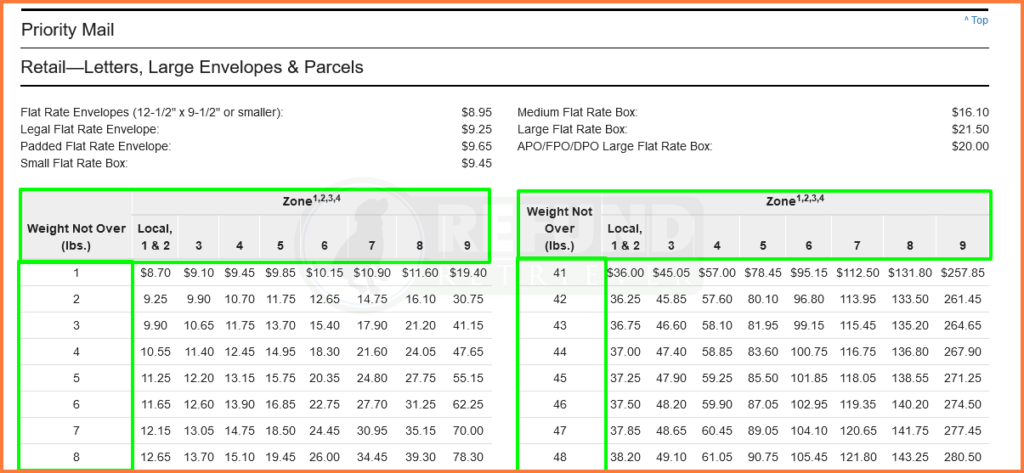
Zones play a significant role in the delivery of goods and services. USPS shipping zone charts focus on the postage price depending on the residential area and the speed of delivery. The National Zone Charts Matrix assists shippers in applying accurate postage rates to mail a package. Postage rates for mail are based on weight and the distance the mail piece travels using zone charts.
Zones differ accordingly; different cities and different maps. For example, if you are in Chicago and your sister is in New York, the map of the United States postal zone in Chicago would differ from that of your sister.
The USPS has approximately nine shipping zones, eight in the continental U.S. Lastly, zone 9 is left out for outlying territories, predominantly islands.
What are the zones of USPS?
- Zone 1: 1- 50 miles
- Zone 2: 51- 150 miles
- Zone 3: 151- 300 miles
- Zone 4: 301-600 miles
- Zone 5: 601-1000 miles
- Zone 6: 1001- 1400 miles
- Zone 7: 1401- 1800 miles
- Zone 8: 1801 miles or greater
- Zone 9: Territories like Guam and Palau.
How To Find USPS Zones
A sure way to find USPS is to use the USPS zone chart. Zone charts are produced by the U.S. Postal Service with already reviewed files of established coordinates to determine the distance between the origin and destination. Charts help identify the distance code assigned to each inception and destination zip code pairing.
How Do Zones Affect Your Shipping Costs?
Shipping costs invariably depend on USPS Zones, and the larger the zone, the higher the price. All shipping works so that zones are the yardstick to measure the monetary payment for such services.
So, the farther the zone you are shipping to from your present location, the more money considering the time and effort to reach such zones. Also, a heavier package will cost more, especially if it is also shipping to a higher number USPS zone.
To reduce the costs of this zoning system, users can utilize flat-rate shipping for heavier shipments. Weight and zones do not affect flat-rate prices. These flat-rate package services are specially for packages within the 70lb range.
The USPS is a cost-effective way to send and receive packages, relying on its top-notch security and ability to deliver without fail. If you own a business that requires extensive interstate shipping and are looking for an affordable, effective shipping option, you should try the USPS. In conclusion, understanding USPS Zone pricing is essential.


